
Current projects
A National Scale N-Retention model of Denmark:
DECODE-3D:
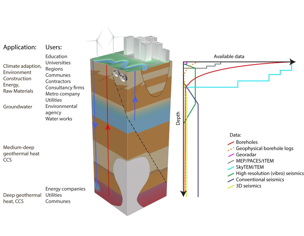
Society has a growing need for correct and updated knowledge about the subsurface. The subsurface is the key to solve a range of societal challenges i.e. climate change, urbanization, raw materials and the green energy transition etc. The project, DECODE-3D, is a first step towards building a national geological 3D model for Denmark, which will deliver relevant, updated information about the geology to be used when solving critical issues in society.
The project, DECODE-3D, will concentrate on the construction of a common modelling concept that both can cover the subsurface down to the basement and at the same time consider the different demands for scale in the various parts of the model. The modelling methods should therefore be adjusted both in relation to the user needs concerning the necessary level of details and scale, and the availability and resolution of the data. The modelling concept will make use of numerical methods to make the modelling efficient and allow for easy updating of the model.
INTEGRATE:
Previous projects
Geologisk model for området omkring Grindsted og udvikling af procesbaseret modelleringskoncept:
Projektets mål har været at danne en geologisk model for Grindsted under udvikling af et modelleringskoncept til procesbaseret modellering, hvor geologisk information om aflejringsprocesser er kvantificeret således, at det kan kobles sammen med geofysisk information uden at skabe inkonsistens. Dette modelleringskoncept er afprøvet for de øverste 150 meter i og omkring Grindsted by og har resulteret i en geologisk model for området, der inkorporerer alle tilgængelige data og geologisk baggrundsviden for området.
Mapfield:

In the research project MapField, scientists, companies, authorities and the agriculture sector will collaborate to develop innovative environmental technologies that will help protect Danish groundwater, streams and fjords against nitrogen pollution while at the same time creating better production conditions for agriculture. MapField will create knowledge about the nature of the subsurface with a few metres accuracy, which is crucial for precise predictions of the water and nitrogen pathways and turnover from the individual field to groundwater and streams in specific hydrological catchments. GEUS is the leading part of the project and the Innovation Fund Denmark supports the project with 18,9 millions.
RESPROB:
Groundwater mapping in Denmark is internationally acknowledged and regarded as a benchmark approach. Massive amounts of data (well logs, geophysical, geo- and hydro-logical data) have been collected. Today these data are combined in a deterministic sequential workflow, where, typically, a single final model represents all available information. While successful, this workflow has some limitations: There is no way to ensure the final model consistency with all information at hand, and there is no way to ensure correct uncertainty quantification.
The main goal of RESPROB is to develop a probabilistic data integration workflow that allows consistent integration of well-log, geophysical and geological data. The resulting probabilistic geomodel should be efficient tool for end-users for informed, data-driven, decision making and for risk assessment.
PSPA (PhD project):

The project Probalistic Seismic Prospect Assessment (PSPA) will develop software as an effecient tool for computing models of the underground from the massive amounts of geophysical data that modern technology facilitates. Elaborate underground models minimize the oil companies risk of initiating expensive drillings in the wrong places which as a result reduces the economic risk considerable.
